A new Online Collections portal will launch on February 9th.
Object information on this site was last updated on January 15th, 2025 and will be static until then.
Search Results:Viewing Record 1 of 1 | |
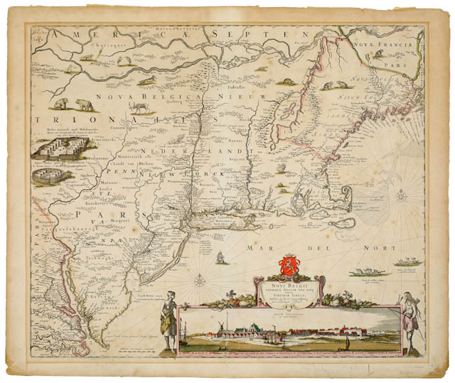
| Maker(s): | Visscher, Claes Jansz.; Visscher, Nicolaes | | Culture: | Dutch (1587-1652); Dutch (1618-1709)
| | Title: | Novi Belgii Novaeque Angliae nec non Partis Virginiae Tabula
| | Date Made: | ca. 1684; after 1682
| | Type: | Map; Print
| | Materials: | Color etching
| | Place Made: | Europe; Netherlands; Holland; Amsterdam
| | Accession Number: | MH 1991.4.85
| | Credit Line: | Bequest of Helene Brosseau Black (Class of 1931)
| | Museum Collection: | Mount Holyoke College Art Museum
|
|
|
Description:
Map of what is now the northeast part of the continental United States and south-eastern Canada. More general area names written horizontal across the land with city and town names written in their location. Illustrations of local animals interspersed over the portion of the map showing the land mass of North America. Three ships shown in the ocean portion of the map. Illustration of two forts along left edge of the map. Inset illustration of the settlement of New Belgium (which would later become New York) in the lower right, set in a frame that is flanked by two standing Native American figures, a woman to the left and a man to the right, and topped by an ornate framing device for the title.
Tags:
maps; Native American; indigenous people; colonialism Subjects:
Etching; Indians of North America; Indigenous peoples Link to share this object record:
https://museums.fivecolleges.edu/detail.php?t=objects&type=ext&id_number=MH+1991.4.85 |
|
Research on objects in the collections, including provenance, is ongoing and may be incomplete. If you have additional information
or would like to learn more about a particular object, please email fc-museums-web@fivecolleges.edu.
|